The bloody basics
Intro to spatial geometry
One of the main activities that geologists face is the creation of maps. In these maps you can find different geologic structures with specific spatial orientations. So, the question is now, how we measure these orientations. Since school you probably have been familiar with the concepts of the cartesian coordinate system (see Fig 1a for reference).
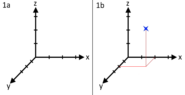
1a: reprensentation of a simple 3-dimesional cartesian coordinate system
1b: reprensentation of a point with the coordinates P(2,2,3) in given coordinate system
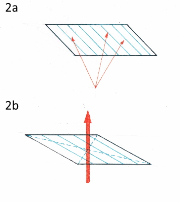
That simple means that there are three spatial directions that are labelled with (x, y, z) or (a, b, c). In order to determine the place of any given point in space, you first must determine the location of the origin. From that you then measure the relative distances of the sections x, y, z to any given point. The hypothetical point in Fig. 1 b therefor has the coordinates (2,2,3). So far so good, but let’s say that we want to determine the position of a plane in the field? Why would you that? Well; I guess that you are all familiar with the concept of faults? A fault is a section that displaces two units of rocks. And this section is often developed as a plane (if you simplify it). For another example you can use the boundaries of two stratigraphic layers, like two layers of sandstone placed onto each other. I think you get the point; planes are quite common. But how do wen measure planes? In classical geometry there are different methods. You can use three vectors (Fig.2a) or a normal vector (Fig. 2b). What is a vector? You remember how we drew a point into the coordinate system in Fig. 1 and labelled it with coordinates? This is basically a vector from the origin to the aforementioned point. Thus, a vector gives you the directions (and indirectly the length) from one point to another. However, the notation is a bit different. Since a vector is a spatial element, we write it as follows:

Now we can use three vectors to build a plane or we define a normal vector. This means that a vector is perpendicular to a plane (see Fig. 2b).
Alright then, but isn’t that extremely complicated? Setting a point of origin and then measuring three distances from that point? Doesn’t that take forever and is prone to mistakes? You are completely right. Remember that geologists are lazy and do not want to do more than necessary. Therefor I shall present to you now: the spherical coordinate system. This functions in a similar way to the cartesian coordinate system. However, in this case you are not using three distances but the vales for x and y are replaced by angles. With these angles you can create a line from the origin into eternity. If you then determine a radius (meaning a distance) on this line, you get a point (see Fig. 3a).
Why do we need Schmidt’s net anyway?
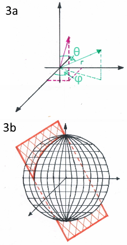
3a: reprenentation of the spherical coordinate system with its attributes
3b: hypothetical plane inside a sphere
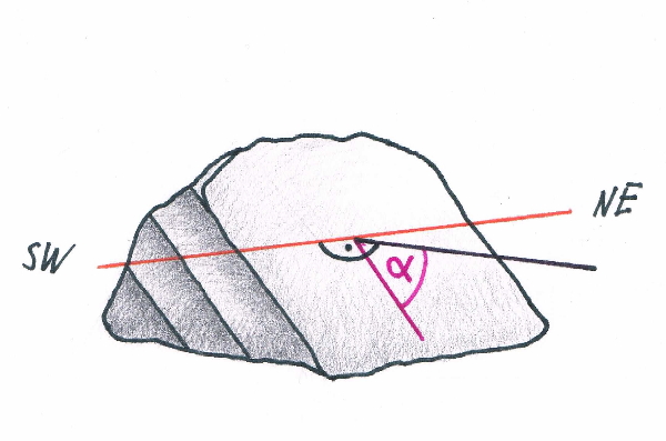
Possibly you might yourself be wondering still why we need that net. Let’s try to satiate this thirst for knowledge, shall we? Have a look at Fig. 4. There you can see a fictional outcrop of layered rock. One of these layers can now be represented as a plane by one dip angle α and the accompanying strike directions. If we now set a GPS point at this outcrop, we can now say that the plane strikes from NE to SW and dips towards SE with the dip angle. Now you must know that instead of letters geologists use numbers to determine the direction. A circle has 360°. Therefor the direction NE is equivalent to 45°. For sake of convenience let’ assume that the plane dips with 45°. With all that knowledge, let’s get to the notation.
In English speaking countries the notation is Strike/Dip angle/dip direction. For strike there is always the strike direction used that comes first, when you go around the directional circle in a clockwise notion starting from the north. Therefor in our example it would be: 45/45/SE.
In German speaking countries (and maybe others as well) we simplify that a bit because we are even lazier. We just give the dip direction and the dip value. Therefor after this notation the example would show up as: 135/45.
With that knowledge you can now draw the orientation of any plane in a geologic map, but you will not be able to do any calculations with it. Therefor we are now (finally) arriving at the Schmidt’s net. What is this net? Well; look at Fig. 5a and you will see it:
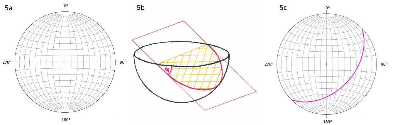
5a: representation of Schmidt’s net
5b: side-view of the intersection of a theoretical plane with a half-sphere
5c: the final picture: the purple circle segment shows the great circle that the plane of the theoretical outcrop in Fig. 4 generates in the Schmidt’s net.
At first glance, this does not really show that much, right? What does this net even represent? Do you remember how I explained the basics of the spherical coordinate system to you earlier? What we are now doing is using such a sphere and slice it in half at the equator. The upper half can go away, we are only interested in the lower sphere. Imagine now that you are looking from above the sphere to the pole and that the sphere is hollow. 0° represents the North, 90° is East and so forth. Now you take a plane with an arbitrary angle and put it into the hollow sphere. If you look from the side (Figure 5b) you will see that the sphere and the plane intersect in a circle segment (we are going to call that intersection line) with each other. Therefor all the lines in the Schmidt’s net are planes which strikes were either N-S or E-W and had different dips; here the difference in dip is always 10°. However, in our given example, the strike was not that, but it was given with 45°-225°. Therefor the tips of the intersection line should touch the circle at the values 45° and 225°, right? Right! Just look at Fig. 5 c and you will know how the intersection line will look like. We call these intersection lines grand circles. If you look closely however, you can see a little cross at the other side of the sphere. Remember how we talked about the normal vector of a plane? This is this normal vector that pinches through the “hull” of the sphere.
You can see now, that this projection simplifies things radically and that we can display the direction of any plane extremely easy now.
And there you have it; the introduction on why we need a Schmidt’s net and what we can see there. In the next section you will learn how to draw planes into one of them by your own.
